I use QGIS 3.22.12, QField 2.7.6 on android (tested with both phone and tablet) and the QfieldCloud.
I built a project in QGIS with 2 vector layers (in geopackages), 2 tables (in the same geopackage) and 1 raster file. The raster file is 12GB in size (*.mbtiles based on google satellite and created with “Generate XYZ Tiles” (tile format = JPG)).
Since the raster file is to serve as the basemap for several QField projects that will be used offline, I would like to use it as a “shared local dataset” (Shared local datasets - QField Ecosystem Documentation). Here, however, I do not succeed.
In detail what I have done:
In QGIS
added 2 vector layers and 2 tables
added the raster file (*.mbtiles) from folder “C:/Prive/basiskaarten”
Copied the *.mbtiles file from my desktop to the folder “…\Android\data\ch.opengis.qfield\files\QField\basemaps” with the exact same name.
I save my QGIS project as a *.qgs file (also tried with *.qgz but with a *.qgs I can check if my raster file is effectively saved as localized) and create a new QFieldCloud project (“Convert currently open project to cloud project”).
On the qfield cloud webpage, I then see the following error message under uploaded project > jobs: “invalid_dataprovider Provider is not valid (provider: gdal, URI:”. (printscreen 3) In Qfield itself, I then see the exact same error message when opening the project. The other layers do load.
Perhaps interesting to add: if I export the project with all files via “package for QField”, and import it into QField like this (i.e. without the QField Cloud) then it does manage to load the *.mbtiles file. So I think the problem is not linked to the file itself.
Imported from GitHub comment by @S1lk3 on 2023-05-10T07:17:17Z
Is there a workaround to get my 12GB satellite image into my QfieldCloud project, by manually copying it to a folder on my QField device? It is not desirable to put this heavy file in the cloud given the high cost. I do want the vector files in the cloud; I want to be able to pull in the changes daily via QFieldCloud.
Imported from GitHub comment by @S1lk3 on 2023-05-10T07:43:33Z
Followed the same process and having the same issue, but with a 10GB satellite image .tif. Also looking to avoid storing this in the cloud due to cost and efficiency.
Imported from GitHub comment by @dougpiercey on 2023-05-11T19:00:40Z
I tried today on Android to follow the instructions here: Shared local datasets - QField Ecosystem Documentation. I created a project on QGIS desktop with a basemap.mbtiles file that resided in the folder I added into the Localized Data Paths. I confirmed that file was not synced when I synced it to QfieldCloud. Then I manually placed basemap.mbtiles into my devices ch.opengis.qfield/files/QField/basemaps/ folder. But when I open the synced project in QField it my basemap.mbtiles does not show up in the layers panel. Interestingly, when I try QField Unstable from the Play Store (which turns out to be a build from December 2022) the basemap.mbtiles layer shows up in the layer panel but does not render anything. I am pretty sure this page is inaccurate Shared local datasets - QField Ecosystem Documentation and this functionality is totally broken (regardless of if you use QFieldCloud or not) unless someone can point me at a working example
Imported from GitHub comment by @max-mapper on 2023-06-21T18:57:55Z
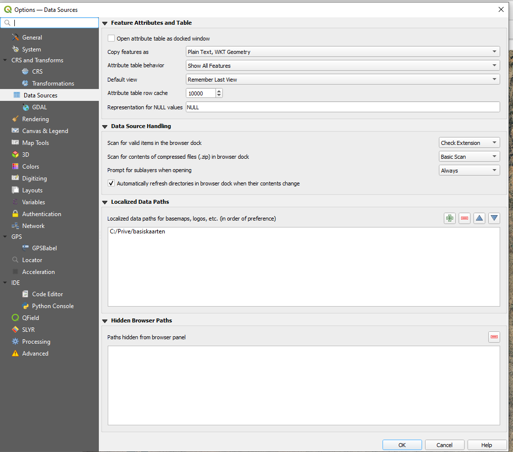
maxogden i work with localized data (raster) paths on many projects. It is working perfectly when syncing via cable. Syncing via cloud does not support local datasets so far, that is what is stated here in this thread.
If you create a local data path in QGIS and put your raster in there, you need to remove the raster from the QGIS project, restart QGIS and then add the raster to the project. Save the project, then sync via cable. To verify if QGIS/QFieldSync recognizes the raster data as coming from a localized path, in QFieldSync options it should look like in my screenshot:
Another suitable workaround for us would be:
A Project which is flagged to be used as basemap, would also be the basemap of other Projects in Qfield. Not just of standalone datasets. (see #4311 )
Imported from GitHub comment by @threalslimtobeeee on 2023-10-31T13:17:27Z
This worked really well between January and mid-March, then something got broken and I cannot get it to work again. I’ve submitted a ticket yesterday on the QFieldCloud website.
Imported from GitHub comment by @jguelat on 2024-04-23T12:27:13Z